The time is nigh.
07 May 2018
Don't Forget Me When I'm Gone
I need to be out of the house in 20 minutes. Updated the "Track Us" page with the link to the actual trip, though it won't begin to populate until I get a coupe miles from home and activate Ryan's Lassie (Spot device). Then to a plane, then to Seattle, then to Anchorage.
The time is nigh.
The time is nigh.

04 May 2018
The Most Direct Route
A co-worker asked me yesterday how long it would take if we were to drive our route without stopping. As expected, the most direct route is still pretty long. Google won’t give you a course from Alaska to Argentina due to the Darien Gap, but it will calculate Alaska to Panama and Colombia to Argentina, and it will provide a measurement across the ocean from Panama to Colombia. Here’s what it comes to:
*The Stahlratte is the ship that will take us from Panama to Colombia. The trip through the San Blas Islands is estimated at 5 days. I didn’t have a chart of the course, so just estimated the mileage by measuring a direct line from Puerto de Cartí to Cartagena.
| Driving Time | ||||
| Section | Hours | (Days) | Miles | Kilometers |
| Anchorage – Deadhorse – Puerto de Cartí | 163 | (6.8) | 8,251 | 13,279 |
| Cartagena – Ushuaia – Buenos Aires | 176 | (7.3) | 8,332 | 13,409 |
| Sub-total | 339 | (14.1) | 16,583 | 26,688 |
| Stahlratte* | 5 | (0.2) | 244 | 393 |
| Total | 344 | (14.3) | 16,827 | 27,081 |
*The Stahlratte is the ship that will take us from Panama to Colombia. The trip through the San Blas Islands is estimated at 5 days. I didn’t have a chart of the course, so just estimated the mileage by measuring a direct line from Puerto de Cartí to Cartagena.
03 May 2018
Loving friends and thoughtful gifts
Last night was our last juggling club for a while. Get a load of these beautiful folks:
Dave and Robin got us some celebratory cigars to smoke when we reach the bottom of South America and a pair of gremlin bells to ward off evil road spirits.
Kent and Kevin got us some patriotic swag and a cool little flashlight/lantern thing.
The Sampson's showed me how well they know me...
One of my graduating seniors gave me gas money. He refused to take no for an answer. (I made him sign it and promise to keep an eye out for it in the future.)
And of course, parents would never let you do this without a satellite tracker...
Some gas cards and other celebration made it into the mix too. Thank you, everybody, for your thoughtful support. We have an amazing and loving and supportive group of friends and family.
 |
| #goodlookingjugglers |
 |
| The only bike I ever rode without a bell I drove off a cliff. |
Kent and Kevin got us some patriotic swag and a cool little flashlight/lantern thing.
 |
| 'Merica! |
The Sampson's showed me how well they know me...
 |
| Protein bars and liquor! |
 |
| I'm going to pay it forward. |
 |
| Share.garmin.com/NickCivitello |
Weather for the First Leg
Weather will be key on this first leg of the trip. We’ll be in the far north and in wilderness much of the time, and we expect it to be cold enough to potentially impact on road conditions. Here’s what we’re looking at:
The first leg of the trip will take us from Anchorage:
…through Fairbanks:
…with a final gas stop at Coldfoot:
…into the far north of Alaska at Deadhorse/Prudhoe Bay:
…then south back through Fairbanks and east to Dawson City in the Yukon Territory, Canada:
…Whitehorse:
…Fort Nelson:
…a run down the lovely Icefields Parkway beginning in Jasper:
…and, to round-out our Canadian stint, a visit to friends in Calgary:
…before we breeze through the conterminous US. After that, the worry will be more about heat, border crossings, and hoping to know enough Spanish.
The first leg of the trip will take us from Anchorage:
…through Fairbanks:
…with a final gas stop at Coldfoot:
…into the far north of Alaska at Deadhorse/Prudhoe Bay:
…then south back through Fairbanks and east to Dawson City in the Yukon Territory, Canada:
…Whitehorse:
…Fort Nelson:
…a run down the lovely Icefields Parkway beginning in Jasper:
…and, to round-out our Canadian stint, a visit to friends in Calgary:
…before we breeze through the conterminous US. After that, the worry will be more about heat, border crossings, and hoping to know enough Spanish.
Shiny side up
As the date draws near (and boy, howdy, is it near!), I find little pockets of trepidation in various caverns of my psyche.
I think the ultimate version of this trip would be to do it over 6 months: solstice to solstice. I’m quite happy with 3 months, though: it fits my present financial capabilities much more closely, methinks. But moving the start of the trip up from the solstice means heading north of the Arctic Circle before summer has had a chance to catch on. Via conversations on ADVRider.com, I came to appreciate that it can snow at any time of year on the North Slope Haul Road. They say, though, that the week following Memorial Day is often a best bet for decent weather up there. Due to the timing of the Stahlratte voyage from Panama to Colombia, we elected to start our trip to the beginning of May instead of the end. Recently, we’ve started watching weather conditions along our route pretty closely. Deadhorse is the clear winner when it comes to frigidity. Over the past several weeks, we’ve watched it climb above and dip back under 0°F, and covet any forecast of highs above 20°F. We’ve prepared for the cold, though, with thermal layers and heated gear. The even bigger concern, for me, are the road conditions.
The first vehicle I actually owned was a motorcycle – the first motorcycle I ever drove, matter-of-fact.
- This will be the longest departure from work I’ve had in my adult life, and many folks have asked about that.
- We’ll be traveling through some areas that are considered security risks, so will need to be wary.
- There will be a lot of borders to cross, so documentation for ourselves and our steel steeds will need to be in order.
I think the ultimate version of this trip would be to do it over 6 months: solstice to solstice. I’m quite happy with 3 months, though: it fits my present financial capabilities much more closely, methinks. But moving the start of the trip up from the solstice means heading north of the Arctic Circle before summer has had a chance to catch on. Via conversations on ADVRider.com, I came to appreciate that it can snow at any time of year on the North Slope Haul Road. They say, though, that the week following Memorial Day is often a best bet for decent weather up there. Due to the timing of the Stahlratte voyage from Panama to Colombia, we elected to start our trip to the beginning of May instead of the end. Recently, we’ve started watching weather conditions along our route pretty closely. Deadhorse is the clear winner when it comes to frigidity. Over the past several weeks, we’ve watched it climb above and dip back under 0°F, and covet any forecast of highs above 20°F. We’ve prepared for the cold, though, with thermal layers and heated gear. The even bigger concern, for me, are the road conditions.
The first vehicle I actually owned was a motorcycle – the first motorcycle I ever drove, matter-of-fact.
 |
| This isn't the actual bike, but it is a GS850G like I had, big ol' WindJammer and all! (pic source: http://img.scgpix.com/listimg/img1_1016/09/img_fUN27kQWsBKYpyu_r.jpg) |

And now I’m driving to the northernmost reaches of Alaska…before temperatures consistently get above 32°F. I just really don’t know what to expect. Dick Proenneke’s “Alone in the Wilderness” remains one of my favorites. Seeing him digging his pathway through several feet of snow and reading about how he thrived in the cold, where 38°F was “balmy” inside his cabin, was inspirational. But the image of several feet of snow sticking in my mind when I start thinking about an area much farther north, on a not-highly-trafficked road, with several high mountain passes just makes me a bit trepidatious.
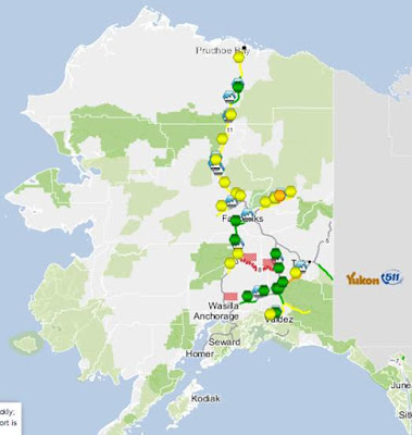
I did just find the Traveler 511 Info website at Alaska.gov. Looks to be quite useful. Most of our route shows yellow (fair) today, which I think I can deal with:

Something to keep an eye on we consider when to drive north.
A pleasant surprise to me: the annual snowfall in Prudhoe Bay is less than 3 feet (source), though the North Slope Borough boasts a grimace-worth 6 feet (source). Wikitravel provides this tentative reassurance: “Travel on the [Dalton] highway during the months of May and September is a bit colder, although travel along the highway is not considerably more dangerous during these months [than the summer months of June-August].” The site reads like an episode of Scared Straight, though like warranted.
So…that’ll be the first leg of our journey. Yippee-ki-yay.
01 May 2018
Yellow Fever no more!
 |
| I had to make my own rows |
Today we went to Passport Health to get our yellow fever vaccine. Apparently it is not a shortage but is in restricted supply... Because that's different.
The only U.S. manufacturer is rebuilding their facility and underestimated the stockpile they would need for the downtime. What we got today was from France and, on paper, is still under clinical study.
 |
| Not the shots I usually order... |
Just a couple of pokes later and we are ready for more borders!

30 April 2018
The bikes are gone!
 |
He has our babies!
However, the pickup wasn't made until yesterday. Nadine and I loaded the bikes on Ryan's behalf because he was out of town.
|

Ryan's bike was a different story.
I don't think I've ever sat on it before and I was really surprised by the way my legs dangled like a little kid's. Between the height of the seat and the width of the seat I was too short to comfortably maneuver the bike.

We tried to see if Ryan's neighbor was home and able to help, but he wasn't and we were at a total loss as to what to do.
The truck driver had a come along winch that we ultimately used to pull the bike up the ramp while Nadine and I kept it from falling over.
The whole process took about 90 minutes. The truck driver was super nice and very helpful.
I can't wait to see him in Anchorage!
 |
| Success! |
Subscribe to:
Posts (Atom)